Since the founding of our communities, organizations, businesses and citizens have stepped forward to build and serve their community. Click on any of the logos below to learn about those who made this website possible! If you would like to learn about becoming a sponsor CLICK HERE!
Steele County, MN
County in Southern MNSteele County, Minnesota, was officially organized February 20, 1855 and originally included what is now known as Waseca County. Re-organization in 1856 established the boundaries we recognize today. The new county was named in honor of Franklin Steele, a St. Anthony governmental contractor and a man of prominence. Steele County is located in the south-eastern part of Minnesota, has 432 square miles, is 24 miles long and 18 miles wide.
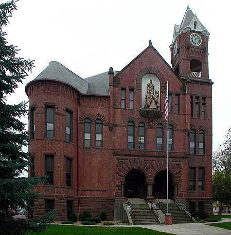
The first county building, built in 1874 at a cost of $5,000, was a one-story brick building which has since been demolished. The historic Steele County Courthouse was built in 1891 for $50,000. It has been remodeled several times and is used solely by the courts. Two courtrooms and one hearing room are available, as well as meeting rooms and office space.
In 1860 Steele County had a population of 2,863 as compared to 21,155 in 1950 and 36,163 as of the 2006 census.
Steele County has numerous streams, natural springs, brooks and lakes. The largest of the streams is the Straight River and the largest lake is Rice lake. Nine mineral springs are located in Owatonna, in an area known as Mineral Springs Park. These springs have been analyzed and show the definite qualities of celebrated springs of this country and France.

- County: Steele County, MN
- Region: Southern MN
Destination Steele County, MN
- Sponsors
- Towns
- Businesses
- Community Organizations
- Faith Organizations
- Festivals and Events
- Points of Interest
- Veterans
Learn how to contribute to any of the above categories.
Towns of Steele County, MN
The small towns of the Midwest are rich in history and a great way of life! Below you can visit and learn about the small towns we call home! Towns that have their name highlighted have become FEATURED TOWNS. Businesses/organizations from these towns have stepped forward as SPONSORS enabling us to include (or will include as acquired) stories and website links to ALL their community organizations (chambers, groups and departments, etc.), stories and website links to ALL their points of interest, annual festivals/events and stories done about their citizens, veterans and faith community. To learn how to become a featured town CLICK HERE!
Businesses of Steele County, MN
The businesses of our towns are truly the lifeblood of each community, click on any businesses below to learn about them, to learn how to add your business to your town and county page CLICK HERE!
Community Organizations of Steele County, MN
Small towns and rural communities throughout the Midwest are looking for ways to strengthen their economies, provide better quality of life, and build on local assets. Here you will find the organizations that stabilize, preserve, and revitalize the small towns and rural areas alike. To submit your organization to be included on your town and county page CLICK HERE!
Events of Steele County, MN
The small towns of the Midwest have long shared pride in their communities through festivals and events! Citizens from each community, working together, continue to offer entertainment options that not only appeal to their citizens, but visitors to their community! Below you will find festivals and events you are sure to want to attend! If you would like to have (DST) include an annual festival or event on your town and county page CLICK HERE!
Faith Organizations of Steele County, MN
Throughout the years faith organizations have not only been an essential part of a town's religious life, but its community life. Below you will find stories about these organizations, If you would like to induct a faith organization to be added to your town and county page CLICK HERE!
Points of Interest of Steele County, MN
The communities of the Midwest have a lifestyle unique to their region — rich in history and points of interest like no other! Below you will find points of interest you are sure to want to visit! To nominate a landmark, historic location, museum, etc. as a point of interest on your county and region page CLICK HERE!
Veterans of Steele County, MN
Veterans come from many walks of life and whether a veteran has severed two decades ago or two days ago, they have made our freedoms possible. Below you will find stories about many who have served. If you would like to nominate a veteran to be included on your town and county page CLICK HERE!


